FOTOGRAMMETRIA ED ELABORAZIONE DI IMMAGINI DIGITALI PER L’ANALISI DEL DEGRADO DELLE INFRASTRUTTURE
Abstract
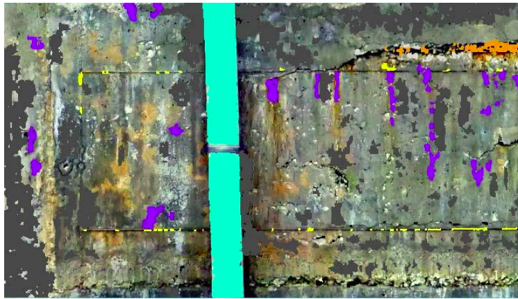
The need to evaluate the level of infrastructure reliability through an in-depth knowledge phase is more essential than ever to guarantee functionality and performance. A large part of the infrastructural heritage, especially in the western world, was built around the 1950s, so it needs a correct and timely analysis for an efficient maintenance programme. This work exploits the photogrammetric technique and the DIP (Digital Image Processing) for the analysis of the decay forms affecting the pylon of a viaduct. Experimental algorithms embedded in the ACM Systems have been tested and compared with traditional image processing techniques. Following a terrestrial and UAV photogrammetric survey, a region of interest of reinforced concrete pillar with decay forms was identified. This region was, at first, analyzed with OBIA (Object - Based Image Analysis) and was subsequently enhanced with ACM Systems. The validation was performed using, as ground truth, a thematic map of the decay forms identified by a concrete expert. Finally, comparisons with commonly used algorithms were made. The results showed that ACMs provide up to 5% higher overall accuracy than common algorithms. Flexibility and objectivity are among the main advantages of the method and pave the ground for the development of a semi-automatic procedure useful for institutions responsible for infrastructure maintenance.
Downloads
Downloads
Published
How to Cite
Issue
Section
License
Copyright (c) 2025 Sara Zollini (Autore)

This work is licensed under a Creative Commons Attribution-ShareAlike 4.0 International License.

