Monitoring Glacier Changes Using Optical Satellite Imagery: The Case of Forni Glacier
Abstract
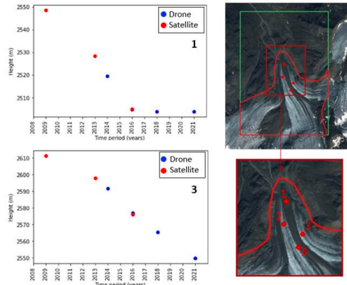
Glaciers are one of the most important indicators of climate change. Monitoring their evolution is, therefore, crucial for safeguarding the Earth’s ecosystem. In this study, exploiting photogrammetric optical satellite processing techniques, we used image pairs from Ikonos-2 and Pleiades-HR satellites to generate Digital Surface Models (DSMs) of Forni Glacier (Ortles–Cevedale group, Italy) and compute its morphological variations between 2009 and 2016. In addition, we used DSMs generated from Unmanned Aerial Vehicle (UAV) acquisitions collected during summer campaigns from 2014 to 2021 for comparison with very high-resolution DSMs on the terminal portion of the glacier including its tongue. To evaluate the glacier height loss, DSMs co-registration was applied to remove DSM biases due to inconsistencies in the georeferencing of the different satellite image pairs, considering the use of Nuth and Kaab algorithm. The DSM height differences after co-registration highlighted a final accuracy of one meter. Results from optical DSMs were consistent with the average annual variation of the glacier suggested by UAV DSMs analysis, confirming an average 5.00 m/y loss on the Forni tongue during 2014-2016. Furthermore, based on both UAV and optical data, melting trends have highlighted how climate change is causing an acceleration in the melting process, with values averaging 3.3 m/y in the period 2009-2013, 3.8 m/y in 2009-2016 and 4.7 m/y in 2009-2021. Our results suggested that despite the limitations related to weather conditions (e.g. cloud coverage) and time revisit, high-resolution optical satellite imagery can certainly be used to estimate relevant morphological variations of glaciers in the order of meter/years, offering the opportunity of monitoring large-scale areas.
Downloads
Downloads
Published
How to Cite
Issue
Section
License
Copyright (c) 2025 Lorenza Ranaldi, Valeria Belloni, Mattia Crespi (Autore)

This work is licensed under a Creative Commons Attribution-ShareAlike 4.0 International License.

