MONITORAGGIO INNOVATIVO DEGLI OLIVI TRAMITE PROXIMAL SENSING: STIMA DEL VOLUME DELLE CHIOME
Abstract
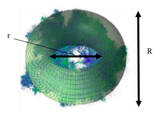
The development of methods and techniques for reconstructing olive tree canopies by point clouds is a long-established topic challenging many researchers. Using Mobile Laser Scanner, we measured single tree parameters in an olive grove in Cartoceto, Marche Region. The area is a well-known geographical indication agreed by Italian law by Protected Designation of Origin (PDO). According to the agronomic practice, we first estimated the canopy volume using geometrical primitives (paraboloid and toroidal) as ground truth. We have finally compared the canopy values with the volumes obtained by mesh algorithms: Convex hull and Alpha shape, to statistically compare pairwise correlation (Paraboloid - Convex hull R2= 0,92 and Toroid - Alpha shape R2=0,91). This preliminary analysis provides a theoretical benchmark for future implementations, such as the possibility of including LiDAR (Light Detection and Ranging) in the mechanized pruning process.
Downloads
Downloads
Published
How to Cite
Issue
Section
License
Copyright (c) 2025 Stefano Chiappini, Roberto Pierdicca, Eva Savina Malinverni (Autore)

This work is licensed under a Creative Commons Attribution-ShareAlike 4.0 International License.

